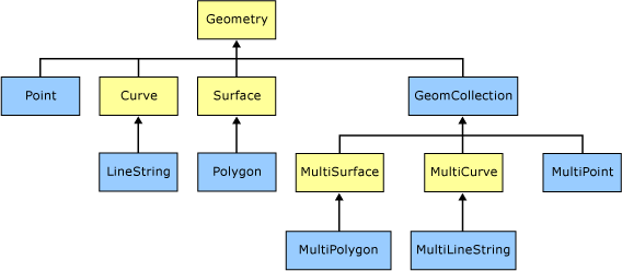
Shapes are the geometry objects that are used to draw an outline or it can be used as real geometry shape for calculation on top of maps (geography). There are 11 usable or instantiable shape objects available in SQL Server. But, we can use only 11 of them and the image shown here is used to quickly identify the instantiable objects mentioned in blue color. In general, child object type properties are inherited from the parent objects.
Spatial Data Hierarchy – Microsoft Image
 These data types are splitting into two categories simple and collections.
Simple Types
- Point
- LineString
- CircularString
- CompoundCurve
- Polygon
- CurvePolygon
Collection Types
- MultiPoint
- MultiLineString
- MultiPolygon
- GeometryCollection
Geography Type
- FullGlobe
It is important to know that some of the methods are capable of handling only simple objects. SQL Server follows the standards of OGC (Open Geospatial Consortium). The following links will give you detailed information about OGC standards and other GIS architecture details.
