GIS file formats are the standards that are used to store the Geo-spatial data. These data formats are created by government entities, educational institution, geological information storage and service organization and etc.
There are many popular open source or proprietary formats available. Following are the most popular format which we are using in day today geography data.
- Raster
- Vector
- Grid
- Others
Raster
Raster data type consists of rows and columns of cells and each cell storing a single value. It uses color code RBG. An external attribute table can be maintained each cell by rows. Raster data can stored in various formats such file-based structure of TIF, JPEG and etc. We can also use RDBMS to store this data as BLOB.
Vector
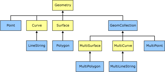
GIS data in vector format contains typical geometry shapes such as points, line, polygon and etc. to represents geological location or regions in the earth. Usually, vector data may also comes with the database that describes the attributes of the shapes. For instance, if we use point on a building the attribute database may have its address, phone number and etc. to provide additional details about that location.
To understand better about raster and vector, it is ideal to have a look at the below given image.
 Vector GIS has more flexible and simplicity to integrate in to the application. It is more developer friendly and simple to storage and use.
An Esri grid is a raster GIS file format used to represent elevation and it is developed by Esri.
There are two formats available now:
- A proprietary binary format
- A non-proprietary ASCII format
There are different organization and their software uses different formats to store GIS data. Below given list is taken from Wikipedia.
Raster:
- ADRG
- BIL
- CADRG
- CIB
- Digital raster graphic (DRG)
- ECRG
- ECW
- Esri grid
- GeoTIFF
- IMG – ERDAS IMAGINE image file format
- JPEG2000 – Open-source raster format.
- MrSID
- netCDF-CF
Vector:
- AutoCAD DXF
- Cartesian coordinate system (XYZ) – simple point cloud
- Coverage – Esri‘s closed, hybrid vector data storage strategy.
- Digital Line Graph (DLG) – a USGS format for vector data
- Enterprise Geodatabase – Esri‘s geodatabase format for use in an RDBMS
- File Geodatabase – Esri‘s file-based geodatabase format, stored as folders in a file system
- Geography Markup Language (GML) – XML based open standard (by OpenGIS) for GIS data exchange
- GeoJSON – a lightweight format based on JSON, used by many open source GIS packages
- GeoMedia – Intergraph‘s Microsoft Access based format for spatial vector storage
- ISFC – Intergraph‘s MicroStation based CAD solution attaching vector elements to a relational Microsoft Access database
- Keyhole Markup Language (KML) – XML based open standard (by OpenGIS) for GIS data exchange
- MapInfo TAB format – MapInfo‘s vector data format using TAB, DAT, ID and MAP files
- National Transfer Format (NTF) – National Transfer Format (mostly used by the UK Ordnance Survey)
- Personal Geodatabase – Esri‘s closed, integrated vector data storage strategy using Microsoft‘s Access MDB format
- Shapefile – Esri‘s open, hybrid vector data format using SHP, SHX and DBF files
- Simple Features – Open Geospatial Consortium specification for vector data
- SOSI – a spatial data format used for all public exchange of spatial data in Norway
- Spatial Data File – Autodesk‘s high-performance geodatabase format, native to MapGuide
- TIGER – Topologically Integrated Geographic Encoding and Referencing
- Vector Product Format (VPF) – National Geospatial-Intelligence Agency (NGA)’s format of vectored data for large geographic databases
Other GIS data storage formats
- Binary Terrain (BT) – The Virtual Terrain Project’s Binary Terrain format
- Dual Independent Map Encoding (DIME) – A historic GIS file format, developed in the 1960s
- Well-known text (WKT) – A text markup language for representing feature geometry, developed by Open Geospatial Consortium.
- Well-known binary (WKB) – Binary version of Well-known text.
- World file – Georeferencing a raster image file (e.g. JPEG, BMP)
Vector format, WKT and WKB are the useful GIS data storage and manipulation formats in SQL Server. We will learn about that in the next blog post.